
My Raleigh M-80
mountain bike, aka Behemoth,
before the ride began in St. Charles, Mo.
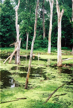
Wetlands such as
this one near Weldon Spring
are common on the Katy Trail.

Bluffs such as this
one near Klondike, Mo., are
among the highlights of the trail between Defiance
and Augusta, one of the centers of Missouri's
wine country.

The Missouri River was high during the spring of
2008, but it only caused minor flooding problems
during the Katy Trail Ride.
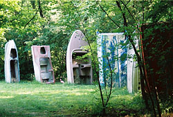
BoatHenge is one of the more distinct man-made
atttractions along the Katy Trail.
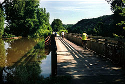
Flooding from the Missouri River in 2008 came
close to overlapping the deck of this bring over
Little Bonne Terre.

Limestone bluffs tower over the Katy Trail and
the Missouri River near Rocheport.

The limestone tunnel near Rocheport.

The high point of the Katy Trail is 955 feet above
sea level near Bryson, Mo.
SUMMARY: A 5-day tour of the 225-mile Katy Trail put on by the Missouri Department of Natural Resources. The ride either goes east from St. Charles to Clinton, as it did in 2008, or it goes from Clinton to St. Charles. The Katy Trail is the United States' longest rail-to-trail project and takes cyclists along the Missouri River and towering bluffs. DNR does a very good job of supporting the ride. I highly recommend using a hybrid for the crushed-limestone trail rather than a mountain bike, unless you use tires with a less aggressive tread.
RIDE WEB SITE:http://www.mostateparks.com/katytrail/index.html
Katy Trail Ride: 2008
One question kept popping into my mind as rode my mountain bike from St. Charles to Clinton on Missouri's Katy Trail:
Can anything go right on this trip?
Let's make one thing clear: I can't blame the trail or the Missouri Department of Natural Resources for any problems I had on this trip. The 225-mile Katy Trail offers plenty of great scenery, and DNR does everything possible to make sure cyclists have enough food, water and support to make it through the five-day adventure.
No, all of the problems I had on this trip were self-inflicted.
Since this year's ride started in St. Charles, Mo., and I live 36 miles away in Belleville, Ill., I figured I would sleep at home in a comfy bed then drive to St. Charles the morning the ride began rather than camp in a city park in St. Charles.
However, I couldn't get to sleep until 1 a.m. That's close to the time I normally go to bed when I work my evening shift on the copy desk at the Belleville News-Democrat. My 5 a.m. alarm came way too early, but I got to St. Charles in time for the start of the day's ride -- 60 miles from St. Charles to Hermann.
Although I was near the end of the riders who took off from St. Charles, the first part of the day went really well. I was riding strong and catching up with a few people. The scenery along the Katy Trail between Weldon Spring and Augusta is among the best on the entire trail with towering bluffs and some close views of the Missouri River.
Although the Missouri River was above flood stage, it was no threat to us on this section of the trail. When you see the river from a car, you don't have any idea how fast the river's flowing. But a closer look reveals swift currents moving tree limbs toward the Mississippi River.
Anyway, I was feeling pretty good until lunchtime in Marthasville. I passed on visiting the lonely folks at the Race Across America time station in Marthasville and headed straight for the Twin Gables, which has the best burgers in town, or so the bar and grill's ad in the trail map booklet promised.
The burger was good, but I slowed to a crawl for the final 25 miles to the trek to Hermann, our stop for the night in the heart of Missouri's wine country. I didn't make it into Hermann until after 5 p.m.
Mistake No. 1: Not enough sleep. Always try to get eight hours of sleep the night before the start of a multiday ride, especially when it's the longest day of the tour.
I assumed the lack of sleep the night before contributed to my slow finish, and it did, but I changed my complete assessment as the week continued.
Once I made it to Hermann, I hurried up and set up my tent so I could get showered in time for dinner at the Stone Hill Winery. As I unpacked my stuff, I found that I left my towel in Belleville. To add insult to injury, I also left my comb there as well.
Mistake No. 2: Most organized multiday tours provide a check list of equipment you should pack. Don't check anything off until it is securely in your bags.
Fortunately, the Katy Trail Ride has shower trucks, and I tore off enough paper towels from the roll to get me reasonably dry. As for my hair, I normally comb my hair straight back, so I was able to put my hair close to its place with the towel.
I've visited the Stone Hill Winery many times over the years and have many fond memories of the place. However, I was too tired to really appreciate the wonderful German music being played, but I did find enough energy to drink a couple of glasses of wine.
I slept reasonably well, but I soon would find out Tuesday morning I needed more.
We had to ride nine miles from Hermann to our breakfast stop in Rhineland, the church hall at the Church of the Risen Savior. The food was great, especially the sausages, but by the time I got there, there was only decaf coffee left.
I managed to trudge my way to Portland, but the sleep deprivation really hit me hard. The fact that the sweep riders at the end of the ride reached me was while I was resting in Portland was a sign that I needed a little help. A park ranger loaded my bike on the car, and we took off toward the North Jefferson trailhead. Almost as soon as we hit the road, I fell asleep.
Mistake No. 3: It's not good form to take the "rest" at rest stop too literally.
After a few snacks at North Jefferson, I was back on the road. When I reached the U.S. 63 overpass, I ran into Paul Skeans. Paul, the superintendent of schools for the Gillespie, Ill., School District, and I have worked together on the Tour de Coal ride in Benld, Ill., since 2006, and it was great to see a familiar face!
Paul started the ride a day late. On his first day, he rode east from Hartsburg until he ran into the bulk of the riders going west, then he turned around and headed back to Hartsburg.
Hartsburg is a tiny town of 108 people, but the people did their best to handle us. Many people allowed us to set up tents in their yards. Despite its size, it the home to one of the locations of the Summit Lake Winery. Paul and I enjoyed a few glasses of wine there.
Although the Mississippi River was well above its banks and causing all sorts of trouble for people in Missouri, Illinois and Iowa, the Missouri River only saw moderate flooding during our week on the Katy Trail. That moderate flooding caused two detours on Day Three of the ride, the stretch between Hartsburg and Boonville.
The first came just north of Hartsburg, and riders could either take a detour that featured a big hill and rough gravel roads or take a shuttle bus to Wilton. I chose the latter option.
Just north of Wilton was a bridge over Little Bonne Terre, a tributary of the Missouri River. The floodwaters came within 6 inches of reaching the deck of the bridge. Near that bridge was BoatHenge, a group of old boats partly buried in an arc. For a somewhat exaggerated history of BoatHenge, visit its Web site!
I looked forward to seeing the stretch of the trail leading to Rocheport, and it did not disappoint. Like the stretch between Defiance and Augusta, the stretch south of Rocheport has bluffs that tower over the Missouri River, and the Katy Trail is nestled tightly between the bluffs and the river.
The section of the trail north of Rocheport also was closed because of flooding, but most of us took the trip to the 243-foot tunnel drilled through one of the bluffs.
The detour put us on U.S. 40 for a brief bit, and I sure wish I would have had my road bike on that hilly stretch, I was really starting to understand why I had the wrong bike -- or at least the wrong setup -- for this trip.
Mistake No. 4: Ride organizers say hybrid or mountain bikes are best suited for the Katy Trail. After my experience on my Raleigh M-80 mountain bike, I would have to say I would have been much happier on a hybrid. At the very least, I should have installed tires with a less-aggressive tread and put my SPD road bike pedals on the mountain bikeinstead of relying on toe clips.
It was my first-ever multiday ride on a mountain bike. Even though I've had a mountain bike for nearly 10 years, I never had gotten around to naming it as I have my two Cannondale road bikes, Old Blue and The Stealth. But after several days on a heavy mountain bike, it earned a name -- Behemoth!
As beautiful as the stretch leading to Rocheport was, the stretch between Rocheport and New Franklin was equally tedious, There's little shade or scenery, and I was sure glad to make the turn toward the Missouri River bridge to Boonville.
I did provide a little "entertainment" for some riders near the now-abandoned station stop of Pearsons. With miles to go before the next trailhead and restrooms, I desperately had to heed Mother Nature's call. I managed to find corn high enough to hide in, but I let loose with a loud "toot" just as a couple of cyclists passed. I think they said something like "way to go" as they passed!
Mistake No 5: If you think you're far enough way from the trail to be hidden from other people, go farther. Sometimes, you just don't know what Mother Nature has in store for you!
The Katy Trail crossed the Missouri on a new bridge, but the drawbridge that took the Katy (Kansas, Texas and Missouri) Railroad still stands. The Union Pacific Railroad, which now owns the bridge, wants to take it down, but groups such as the Save the Katy Bridge Coalition and the Missouri Bicycle Federation want it to remain standing because of its historic significance and because it would keep the Katy Trail right-of-way intact.
Our campsite for our night in Boonville was the former site of the Kemper Military School, which closed in 2002. One of the buildings houses a YMCA, but the rest of the building sit idle and show clear signs of neglect. It's sad to see such fine buildings go to waste.
After a tasty french toast breakfast served up by The Pancake Man, Jim Kuper, we took off on what many describe as the most strenuous part of the trail, which included a climb up Lard Hill from the Missouri River Valley up to the plains of west-central Missouri.
The 13 miles of shade after Pilot Grove were greatly appreciated, as were the homemade cookies sold by a Mennonite family near Clifton City. I again found myself going slow through the shady part after a strong ride in the hilly section.
Mistake No. 6: Be sure you get enough miles of training before undertaking a multiday trip. I had a couple of good excuses: I spent much of the spring organizing the Tour de Stooges and The Gerry Frierdich Road to Recovery Ride, a worthy fundraising ride to help a fellow cyclist paralyzed when he was struck by a pickup truck. An extremely wet spring and a week of the flu also didn't help.
The fourth day ended in Sedalia. My first impressions of Sedalia weren't good. The Katy Trail goes off the railroad right-of-way in the eastern part of the city and goes through neighborhoods that have seen better days. Downtown Sedalia has some neat buildings, but no obvious signs of a concentrated effort to revitalize the downtown business district.
Our final campsite was in Liberty Park, which is a nice city park in a nicer part of town. The ride had been blessed with lots of sunshine and temperatures no higher than the mid-80s, but a massive thunderstorm rolled through town and knocked down my tent, leaving lots of drenched items, including my cell phone. I was in a really crabby mood as I moved my stuff into a building to sleep, and I didn't get much sleep because I was so worried about keeping others awake with my snoring.
Mistakes No. 7 and 8: Make sure your tent stakes are strong enough to handle heavy winds, and carry your cell phone with you -- or least wrap it up in a plastic Ziploc bag.
We had another breakfast from The Pancake Man, then we took off on the final stretch to Clinton, the western end of the trail. We hit the high point of the trail between Green Ridge and Bryson, and I liked the rolling plains near that section of the trail.
The ride came to an end at the Benson Convention Center, a very nice facility for a small city. Despite the pitfalls I has to contend with, I did enjoy my time on the Katy Trail.
I hope to bike Katy Trail in its entirity someday. Next time, I will be much better prepared so I can concentrate more on all the wonderful things the Katy Trail has to offer.